

Drones have increasingly become popular as an efficient way to conduct surveillance and mapping of remote areas. This technology is utilized in various applications, such as in engineering surveying, archeological surveying, location surveying, and surveying hazardous areas. In the field of aerial remote sensing, drones are being used to map and survey vast tracts of land.

Surveying with Drones
Surveying with drones is an effective and accurate way to capture detailed topographic information. The drones are equipped with image-capture systems and advanced navigation sensors to map out the terrain with ease. Drones enable more accurate and faster surveying than unaided ground-based surveying. This helps to save time, as well as reduce the use of hazardous chemicals for analysis, mapping and surveying.
Applications of Drones in Surveying
Drones are increasingly being used in land surveying, construction and infrastructure engineering. Drones are used for photogrammetry, which is the the process of acquiring and analyzing geographically referenced imagery. This helps to create accurate three-dimensional models of the land, structures and other features. They are also used for volume measurement, land and vegetation surveys, roof inspection, site surveys and as-built documentation.
Another notable application of drones is in environmental monitoring. Large areas of land require efficient mapping, and drones provide a way to remotely measure and monitor land features. For example, drones can be used to detect pest infestations, flooding and vegetation health. This helps to measure the health and progress of crops, as well as detect any anomalies in water chemistry.
Finally, drones are also useful in disaster management. During times of disaster or emergency, they can be used to provide quick and accurate mapping of affected areas. This helps to identify damages quickly, as well as monitor the health and safety of citizens in the area.
FAQs
What are the benefits of using drones for surveying and mapping?
The main benefit of using drones for surveying and mapping is the speed and accuracy of the process. Drones are highly efficient at mapping vast areas of land with greater detail than traditional ground-based surveying. Drones are also more cost-effective than traditional methods, and require less hazardous chemicals for analysis.
What applications are drones used for in surveying?
Drones are used for a variety of surveying tasks, including photogrammetry, volume measurement, land and vegetation surveys, roof inspection, site surveys and as-built documentation. They are also used in environmental monitoring and disaster management.
If you are looking for California Landfill Calculates Remaining Airspace, Tracks Compaction you’ve visit to the right page. We have 4 Images about California Landfill Calculates Remaining Airspace, Tracks Compaction like Surveying and mapping drones in the field of aerial remote sensing and also California Landfill Calculates Remaining Airspace, Tracks Compaction. Read more:
Drone Mapping – Survey – Inspection. FAA Certified Drone Pilot
olympicaerialsolutions.com
Find the most innovative advanced quadcopters currently available today.
Feel the revolutionary technology of the advanced unmanned aerial vehicles on the market.
Over the years, unmanned aerial vehicles have grown in popularity tremendously. From capturing breathtaking aerial shots to delivering packages, they have transformed how we do things. With constant improvements in technology, today’s UAVs have evolved into increasingly sophisticated and provide many capabilities unlike any previously.
At our shop, we offer the cutting-edge drones that exist. These remote-controlled aircraft have been crafted with exactness and advanced technology to satisfy the demands of both amateurs and experts equally. With the capability to fly longer distances, faster, and more exactly than ever before, our drones are the optimal tool for airborne shooting and filming.
Whether you’re looking to film stunning aerial footage of a wedding, real estate property, or simply hoping to boost your filmmaking talents, our advanced drones are the optimal resolution. With attributes like smart obstacle detection, extended-range transmission, and premium cameras, our drones are assured to uplift your picture-taking and videography expertise to new heights.
So, why are you delaying for? Discover the forthcoming of drone innovation at present and avail from our advanced drones. With our easy purchasing system, you can receive your UAV sent right to your front door. Don’t wait, acquire yours at once!
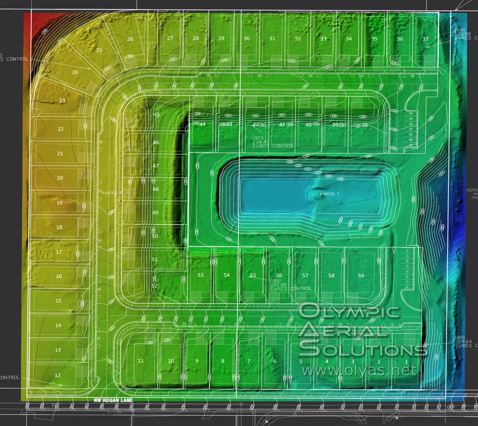
Surveying And Mapping Drones In The Field Of Aerial Remote Sensing
www.dronefromchina.com
Uncover the cutting-edge unmanned aerial vehicles currently available on the market.
Try out the innovative technology of the advanced drones in the industry.
As time has passed, drones have grown in popularity tremendously. Starting with taking amazing overhead pictures to transporting packages, they have transformed how we do things. With constant improvements in technology, today’s drones have evolved into progressively sophisticated and provide numerous features unparalleled to any previously.
At our store, we supply the cutting-edge quadcopters that you can find. These flying devices have been crafted with precision and advanced specs to meet the demands of both amateurs and professionals similarly. With the potential to travel farther, faster, and increasingly exactly than previously, our quadcopters are the ideal instrument for aerial picture taking and filming.
Whether you’re seeking to capture awe-inspiring airborne videos of a wedding, real estate property, or just hoping to boost your filmmaking skills, our innovative drones are the ideal resolution. With attributes like clever obstacle detection, extended-range transmission, and top-notch cameras, our quadcopters are certain to elevate your picture-taking and videography abilities to new heights.
So, what are you hesitating for? Try the forthcoming of drone innovation today and avail from our advanced drones. With our straightforward ordering system, you can get your UAV sent directly to your doorstep. Don’t wait, get yours at once!
How Accurate Is Your Drone Survey? Everything You Need To Know.

geoawesomeness.com
Explore the most cutting-edge drones presently in the industry.
Get a taste of the groundbreaking technology of the advanced quadcopters currently available.
Over the years, unmanned aerial vehicles have risen in use tremendously. Starting with capturing stunning aerial shots to transporting packages, they revolutionized the way we do things. With constant improvements in technology, today’s drones have evolved into progressively sophisticated and provide numerous capabilities unlike any before.
At our boutique, we offer the cutting-edge UAVs that exist. These remote-controlled aircraft were crafted with precision and innovative specs to meet the demands of either hobbyists and specialists similarly. With the ability to travel extended ranges, faster, and more precisely than previously, our drones are the perfect tool for aerial picture taking and video recording.
Whether you’re seeking to record stunning aerial videos of a wedding, real estate property, or simply aiming to boost your video-making skills, our innovative drones are the optimal solution. With attributes like intelligent obstacle detection, extended-range transmission, and high-quality cameras, our drones are assured to uplift your picture-taking and videography skills to a whole new level.
So, why are you hesitating for? Discover the forthcoming of drone technology at present and take advantage from our cutting-edge drones. With our simple buying procedure, you can get your drone shipped immediately to your doorstep. Don’t hesitate, grab yours today!
California Landfill Calculates Remaining Airspace, Tracks Compaction
www.propelleraero.com
Uncover the advanced drones presently today.
Try out the revolutionary features of the most sophisticated unmanned aerial vehicles on the market.
Over the years, unmanned aerial vehicles have increased in popularity tremendously. Starting with taking stunning aerial shots to delivering packages, they have transformed the way we conduct activities. With constant developments in technology, today’s UAVs have become increasingly sophisticated and provide numerous capabilities unparalleled to any previously.
At our boutique, we supply the cutting-edge drones that are available. These flying devices were crafted with exactness and advanced technology to fulfill the needs of both hobbyists and professionals equally. With the ability to fly extended ranges, faster, and increasingly exactly than previously, our quadcopters are the optimal instrument for airborne shooting and video recording.
Whether you’re seeking to capture breathtaking airborne videos of a wedding, real estate property, or simply aiming to boost your video-making skills, our innovative drones are the ideal solution. With features like clever obstacle sensing, long-distance transmission, and high-quality cameras, our drones are assured to elevate your photography and videography expertise to a whole new level.
So, so are you delaying for? Discover the future of drone technology at present and benefit from our cutting-edge drones. With our straightforward purchasing procedure, you can have your quadcopter delivered right to your doorstep. Don’t procrastinate, acquire yours today!